Cascadia Subduction Zone
A 1000 km fault zone from Northern Vancouver Island to Cape Mendocino
THIS ZONE HAS BEEN REVISED
The M 8, originally forecast for Dec 2025, is now expected Dec 2026.
_________________________________
Defined by the Pacific Northwest Seismic Network in the caption to Fig. 1, this 1000 km fault zone extends from Northern Vancouver Island to Cape Mendocino, California.
However, only 400 km further north of Vancouver Island lies Moresby Island off the coast of British Columbia, Canada: here the USGS records show that M 7.8-8.0 earthquakes occur. Ecologically, such large events do not occur in isolation.
Figure 1 shows the sequence of largest annual earthquakes within 1200 km of the Cascadia Earthquake of 1700, since Moresby Island's M 7.8 of 2012.
The size of these largest annual earthquakes fell to a mathematically critical low in 2017 before rising to a major M 7.0 foreshock* (FS) on Dec 5, 2024, off Cape Mendocino at the southern end of the CSZ – a region also at the northern end of California's extremely active San Andreas Fault.
A Magnitude 8 (not a M 9) in Dec 2026?
A magnitude 9 is not possible yet – it is precluded by mathematical and statistical modelling based on the author's new ecological perspective and studies of earthquake population dynamics for over 100 of the world's important earthquakes.
However, if there is a M 8 earthquake in 2026, as seems likely from the new Fig. 1, then it may well be the foreshock to any future M 9 which current mathematical modelling indicates would then be possible by 2027, earlier than previously expected by this author.
From the size and timing of earthquakes in Fig. 1, modelling forecasts a possible M 8.15 event due about the first week of December 2026. The estimated magnitude was determined mathematically from the data for Fig. 1 in relation to a single linear model for one hundred past mainshocks worldwide. The average error margin for over 100 retrospective forecasts has been approximately +/- 0.2 M for all mainshocks, regardless of magnitude.
Successful Prospective Forecast for M 7.0 off Cape Mendocino, Northern California, Dec 5, 2024
The exact magnitude and day of this possible 'foreshock' was forecast by the author’s ecological and mathematical modelling and the event fell as expected within 150 km of the Cape and was advised ahead by email to several contacts in Australia and California.
Although this quake was a ‘mainshock’ for the Cape Mendocino region, there is considerable ecological modelling evidence that it was a foreshock to the upcoming magnitude 8 expected possible by next December, 2026.
This became quite apparent as a possibility in the author’s ‘timing modules’ during the lead up to the Cape’s M 7.0 during late 2024 when it’s position in the mathematical and graphical models was far more that of a foreshock than a mainshock.
Further research models covering the full Cascadia Subduction Zone (like that shown in Fig. 1) soon revealed the likely true status of the Cape’s M 7.0 as a foreshock to a much larger upcoming mainshock which all the author's modules agree will be a Great Earthquake – coming much sooner than anyone realised.
Cape Mendocino:
southeastern end of CSZ.
“A magnitude 8 earthquake in the Cape Mendocino region next December 2026? Not a magnitude 9!”
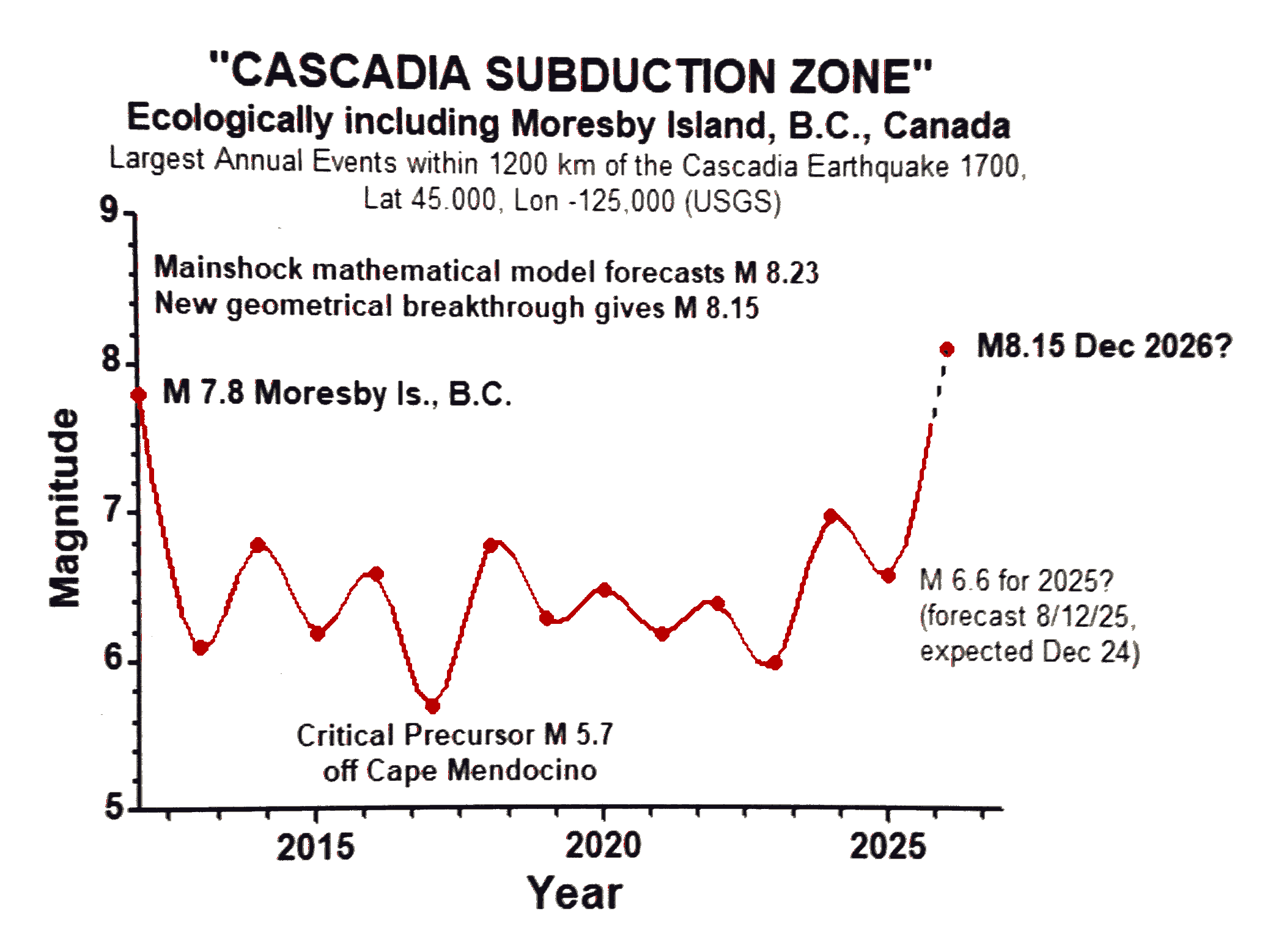
Largest Annual Earthquakes 2012-2025 within 1200 km* of the Cascadia Earthquake, Jan 27, 1700. Epicentre at Lat 45.000, Lon -125.000 (USGS). The Pacific Northwest Seismic Network (https://www.pnsn.org/outreach/earthquakesources/csz) says that "The Cascadia Subduction Zone (CSZ) "megathrust" fault is a 1,000 km long dipping fault that stretches from Northern Vancouver Island to Cape Mendocino California". Ecologically, this zone is extended for the above study some 400 km further north to include Moresby Island where where large earthquakes to magnitude 8.0 occur - such earthquakes do not occur in isolation.
*Excluding inland earthquakes.
Figure 1

“A magnitude 8 earthquake in this Cascadia Subduction Zone
will have the potential to cause very significant land-subsidence,
coastal flooding, and a widespread tsunami”
Photo by Aditya Rajguru on UnsplashA Magnitude 8 (not a M 9) in Dec 2026?
A magnitude 9 is not possible yet – it is precluded by mathematical and statistical modelling based on the author's new ecological perspective and studies of earthquake population dynamics for over 100 of the world's important earthquakes.
However, a M 8 event occurring now could well be the foreshock to any future M 9 which current ecological modelling indicates is unlikely before 2027 at earliest.
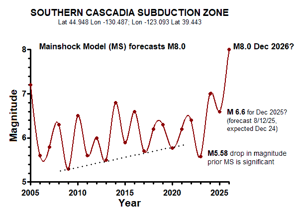
Figure 2.
Largest Annual Earthquakes 2005-2025 in the 'Southern Cascadia Zone' which is defined here as a rectangular region (coordinates: Lat.44.948 Lon -130.487; Lon -123.093 Lat 39.443 ) extending south from the Cascadia Earthquake of 1700 (offshore from Lincoln, Oregon, below Portland) to Montevideo below Cape Mendocino in Northern California.
**Data were analysed with a spline curve generated using GraphPad Prism version 5.01 for Windows, GraphPad Software, San Diego, California USA, https://www.graphpad.com

Where will the forecast M-8 earthquake hit?
The ecological evidence suggests that it will be generated in the Southern Cascadia Subduction Zone (CSZ) somewhere from mid-Oregon to Cape Mendocino in Northern California.
There are already several important pieces of evidence supporting the likelihood of a Southern CSZ M 8 event:
The M 7.0 ‘foreshock’ of Dec 5, 2024, occurred on the large Mendocino Fault Zone (MFZ) only 85 km offshore and near the famous Mendocino Triple Junction between the Pacific, Gorda, and North American plates, which is a very active region.
The M 5.7 ‘Critical Precursor’ of Sep 22, 2017, (for the entire CSZ as given in Fig. 1) also occurred in the Mendocino Fault Zone, but a further 125 km west of the M 7.0 foreshock. The author discovered the so-called ‘Critical Precursors’ which are mathematically important in forecasting the size of a forthcoming regional mainshock in conjunction with a worldwide linear model for 100 mainshock earthquakes ranging from M 5.8 – M 9.5.
The M 5.58 of May 21, 2023 (Fig. 2), represents a significant sharp drop in the sequence of largest yearly events just one year prior to the rise to the M 7.0 foreshock. This M 5.58 is a key drop in magnitude which also occurred in the Mendocino Fault Zone, only 18 km from the M 7.0 'foreshock'.
The regional data for Fig. 2 excludes the northern Canadian portion of the Cascadia Subduction Zone and yet the mathematical modelling of events still forecasts an approximate M 8 in keeping with other evidence above that this large event is most likely further south.
Hazards
This forecast CSZ M 8 earthquake, possibly December 2026 will have the potential to cause a very significant land-subsidence, coastal flooding and a widespread tsunami (Increased flood exposure in the Pacific Northwest following earthquake-driven subsidence and sea-level rise | PNAS).
Any shaking about the period of a forecast event for December 2026 should be taken seriously. Currently, no other period is considered likely or dangerous, but all models are updated regularly with the latest events.
‘It is better to be sure than sorry’ so please heed the instructions of the authorities for large, potentially damaging earthquakes. If there is any shaking, stay away from the coastline during early December 2026 when it could be very hazardous if this forecast is correct; also,
please ensure you read the Disclaimer.